
Hopping down the Exuma Cays, Post #25-5
- sondrawinter
- Feb 2, 2025
- 4 min read
Updated: Feb 8, 2025
Wednesday, January 22 to Thursday, January 30, 2025
Nassau, New Providence Island to anchorage at Big Majors Spot near Staniel Cay
78 nautical miles (90 statue miles)

Nassau
While in the Nassau area, we explored the eastern side of the town, and Athol Island, where we had anchored. One day was entirely spent onboard Utopia due to heavy winds, which resulted in a very rocky, wobbly, lumpy anchorage the following two days. During our last afternoon, we visited The Hideaway, a floating restaurant and bar between the anchorage and Athol Island.


Exploring Nassau | Surprise visit from pigs | Ruins of Athol Island
New Providence Island to Normans Cay, Exuma Cays
41 nautical miles (48 miles)
For our crossing to the south, we decided to go around the Yellow Bank, aiming for an area between it and the White Bank, adding 5 nm to the day. Monday morning (1/27) the sun peaked out as we weighed anchor but dipped behind a mostly cloudy sky as the day progressed. The intermittent sun located directly in front of us made it difficult, if not impossible, to see any coral heads in the bank, so perhaps the detour around the Yellow Bank was a wise choice.
Once past the banks, the engine was cut off and we enjoyed a close-hauled sail for three hours. With winds between 12 & 15 knots, Utopia moved along at 5.5 to 7 knots over the ground. The anchor was set at Normans Cay of the Exuma Cays in very cloudy and breezy conditions, just before it started to rain the rest of the afternoon and into the evening.

Morning brought a big change in weather conditions. Coffeetime in the morning was so peaceful and quiet with only the sounds of the waves breaking on the coast of Norman Cay and the light lapping of water on the bow of Utopia, a stark difference from Nassau. This turned out to be our first full sunny day in the Bahamas, a wonderful welcome to the Exumas.
After a trip to Norman Cay to stretch our legs, and to hunt for a trash can mentioned in some review of the anchorage, we hoisted the dinghy, with the bag of trash still inside, and weighed anchor at 10 a.m.
Shroud Cay, Exuma Cays Land and Sea Park
It was a very short motoring trip as we only moved 6 nm. During the shallow portions Jimmy stood on the bow as we weaved our way down to Shroud Cay.

Shroud Cay is the northern island of the chain of islands located inside of the Exuma Cays Land and Sea Park. We were able to grab the last mooring ball, although there is plenty of anchoring available if a ball was not available. We stayed two nights at this somewhat bouncy anchorage, although this was a big improvement from our stay in Nassau. While here we did a couple small hikes, swam, and explored the area by dinghy.
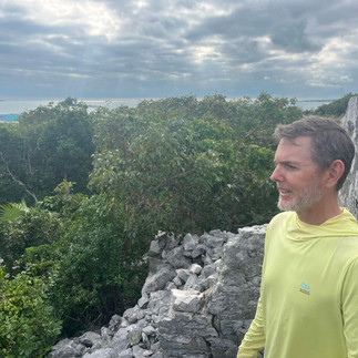
The hikes were short, and the terrain was mostly covered with sharp rocks. One of the hikes was impromptu and done without shoes; this is something I do not recommend. On that hike we reached an elevation of 60’ with great views of the Bank and the Sound sides of the island.


One of our dinghy trips down a creek with shallow spots needed to be done at high tide, so we left Utopia at 7:30 a.m. to reach the creek with the 8 a.m. high tide. We drifted along the creek from the Bank side all the way to the Sound side, then used the motor to return back to the Bank side. We got to clearly see some big turtles on this creek. We have noticed that we are inexperienced with getting off beaches with winds and waves pushing the boat back to shore. Maybe over time we will have a better feeling on how to do this with less awkwardness.
We also did a little bit of snorkeling around Utopia. Just like last year, I need refamiliarize myself with the mechanics of snorkeling. I am comfortable in the water, but that comfort drops when there are a lot of waves, then add in breathing through a snorkel to further reduce my comfort. After swimming on the surface to get used to the snorkel, I tried to dive under water but forgot to hold my breath. I ended up just swimming laps around the boat breathing through the snorkel. Hopefully, I’ll have a higher comfort level next time we snorkel.
Big Majors Spot, Exuma Islands
On Thursday (1/30) we moved 31 nautical miles south. The winds were in our favor again as we had a great five-hour, engineless sail. As soon as we had the hook set adjacent to Big Majors Spot, we spotted something in the water. My first thought was “is that a rock I totally missed as we came in to set the anchor???” But when the rock moved under the boat, we realized it was a nurse shark. Two more followed the first one.
Just like the last two anchorages, the water is so clear and beautiful. I am looking forward to exploring the area before we leave on Sunday to finish our “fast” trek down to the George Town area of the Exumas.

There are a few photos of Nassau, Athol Island, Normans Cay and Shroud Cay that are not shown above available by clicking the button below.
Post # 25-5; See link below for previous post, # 25-4


Comments